Wildfire
Fire Simulation
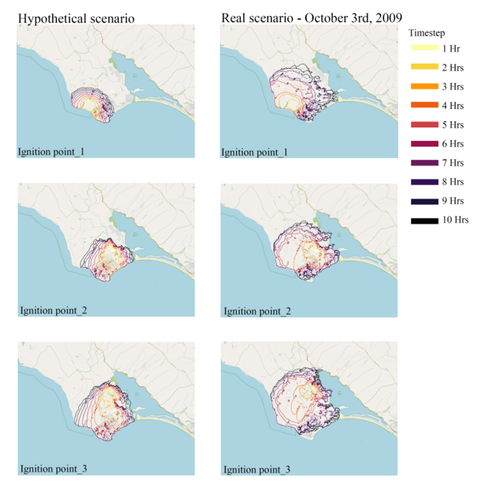
Forest fires are extremely complex events that are becoming increasingly frequent and violent. Fire development is subject to a wide variety of variables that make it a difficult phenomenon to predict and model, so there are a variety of computational models that can relate these variables such as Farsite or Elmfire. To proceed for a simulation the software needs a set of input data related to terrain orography, fuel, and weather conditions, which are the factors that most influence fire behavior. However, predicting the possible dynamics that a fire may assume once ignited, however affected by uncertainty, is extremely useful in directing well in advance all those operations that can be put in place to prevent the fire from impacting people.
Simulating scenarios based on real data and that can show potential likely scenarios, as was done for example for the Bolinas case study or for cities in Marin County is important not only to understand what the impact of the event is itself but also its impact on the road network and the possibility for people to find a safe place.
Testing wildfire evacuation strategies and coordination plans for Wildland-Urban Interface (WUI) communities in California
In the event of a wildfire, government agencies need to make quick and well-
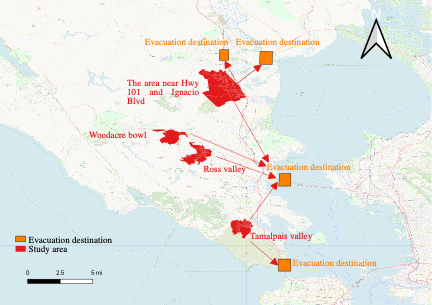
informed decisions to ensure the safe evacuation of people. Small communities in Marin County with an intermix of residences and flammable vegetation in Wildland-Urban Interface zones often lack resources to conduct dedicated evacuation studies. Consequently, this study uses a framework of wildfire and traffic simulation to test the performance of potential evacuation strategies, including vehicle reduction via car-pooling, phased evacuation with staggered evacuation times by zones, and prohibition of street parking in four representative areas of Marin County: Woodacre Bowl, Ross Valley, Tamalpais Valley, and an area near Highway 101 and Ignacio Blvd.
Accessing Potential Factors of Wildfire Evacuation in Marin County, CA
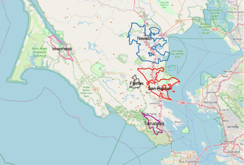
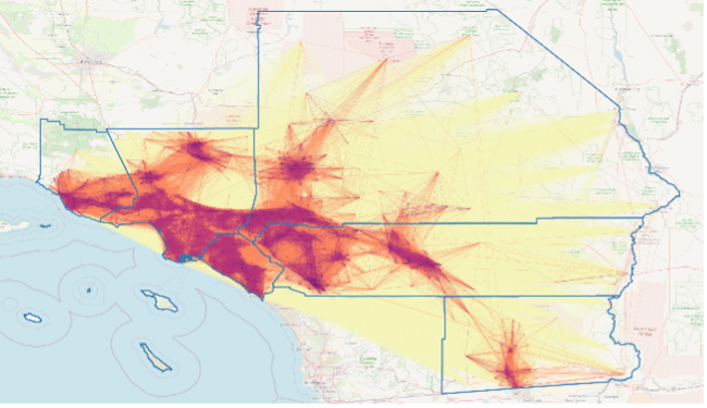
In this study, we address possible factors that might affect wildfire evacuation within Marin County, California. Such risk factors are incorporated within an integrated model involving fire, communications, and traffic. Five communities within Marin County were selected as case study areas to facilitate understanding about specific risks that communities might encounter: Fairfax, Novato, San Rafael, Tamalpais, and Inverness.
First, at the macro level, Marin County takes the responsibility to identify risks for the whole county. Marin Wildfire Prevention Authority (MWPA), an organization that provides resources and best practices to reduce wildfire risk, identifies wildfire threats county-wide as well as risks for specific communities. Second, meso level problems are observed at local levels where five communities that present specific risks for evacuation were selected. For example, populations who need special assistance, like school children and senior citizens, are considered. School parents and elderly care facilities within and near areas at risk of wildfire are identified and incorporated into the models. Third, at the micro level, selected agents that create bottlenecks for each study area are analyzed. This agent-based approach tracks the trajectory of agents who take the longest evacuation times. By doing so, the most detailed level of analysis is achieved by assessing the patterns of the agents’ movement measured by time.
Using this integrated model of fire, communications, and traffic, Meso-level study found that in communities like Fairfax, Novato, and San Rafael, planning is required to distribute limited resources between noon to 2pm. Such a finding was based on the result that the number of 911 calls analysis was concentrated around that time range. Therefore, sharing resources by creating inter-community networks is suggested.
Micro-analysis presented agent level evacuation paths by time, showing where the most congested areas were and at what times. The time and areas of congestion varied across communities. However, some similarities are also observed. Fairfax, San Rafael and Tamalpais commonly had evacuees with relatively longer evacuation times concentrated around nearby areas rather than being distributed throughout the community. But the locations of the agents’ congestions – between origin and destination – differed, requiring further study on specific risk factors other than communications and traffic that might affect each community.
Earthquake Traffic
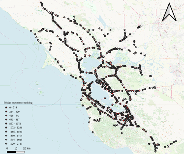
Determination of Recovery Bridge Corridors by Comparing Post EQ Network
The goal is to identify simple, yet accurate, design heuristics that can be used to determine whether a bridge should be designed to a Recovery Bridge (RB) performance standard or an Ordinary Standard Bridge (OSB) performance standard. The proposed design heuristics are based on combining and ranking a set of empirical indicators or metrics derived from one-off regional traffic simulation analysis that considers a bridge’s corridor/network dependency, damage fragility/severity, and critical facility access. The validity of the proposed design heuristics will be verified by conducting numerous HPC based “earthquake, bridge damage, traffic disruptions” scenario simulations for the road networks in the San Francisco Bay Area.
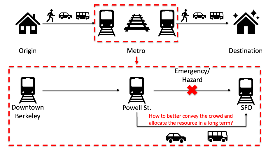
Transit Systems Vulnerability in the San Francisco Bay Area
Located on the tectonic boundary with multiple active faults, notably the San Andreas, the San Francisco Bay Area is highly vulnerable to earthquakes. United States Geological Survey (USGS) predicted that the possibility of an earthquake measuring magnitude 6.7 occurring in the San Francisco region within the next 30 years is 72%. According to experience from the past seismic events, these hazards and emergencies can greatly affect the normal operation of the transportation systems and the mobility of residents. It will be critical for the relevant transit agencies and governments to be better prepared.
As the speed and success of recovery can be enhanced with coordinated/comprehensive planning and protocols, a detailed long-term recovery plan can provide guidance to agencies and local governments to accelerate the recovery process. This multi-phase project aims develop a regionwide multi-modal traffic simulation tool to help with the planning and policy-making during the recovery stage after an earthquake.
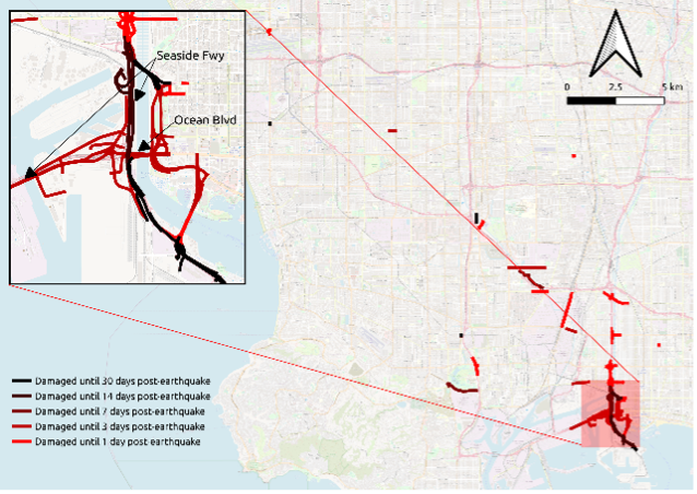
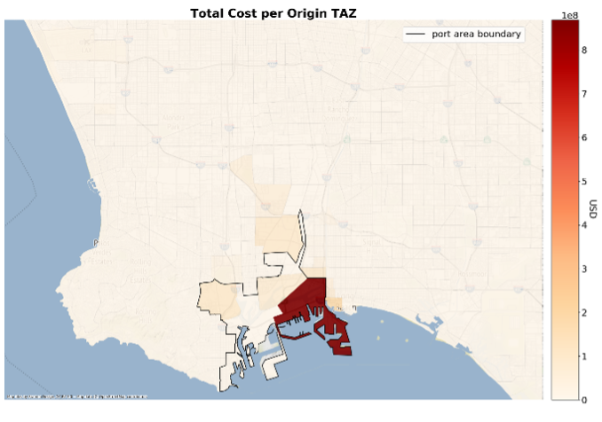
A granular framework for modeling the capacity loss and recovery of regional transportation networks under seismic hazards: a case study on the Port of Los Angeles
This project aimed to apply granular methods in bridge and traffic modeling to a regional transportation network to quantify a hypothetical earthquake’s impact to the network and its users. An image-based method is used to generate structure-and-site-specific bridge models for the Los Angeles area while a semi-dynamic agent-based traffic model is used for traffic simulation. The output from the aforementioned models is then used as input to a simple cost model to estimate direct and indirect costs to the system and its users.
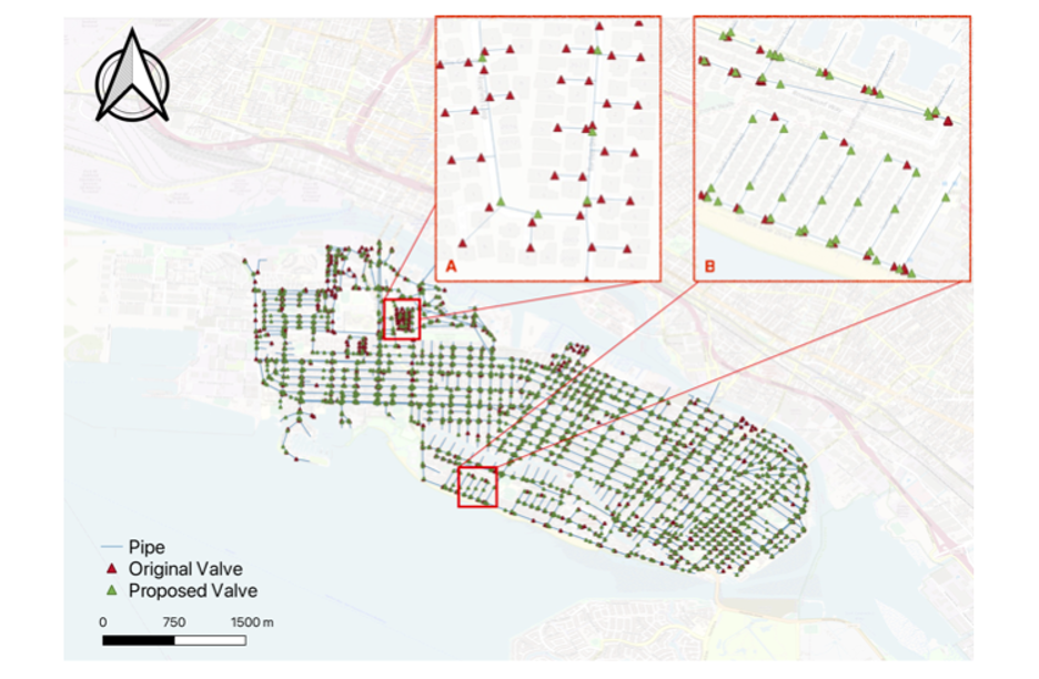
Pipeline
Importance of Isolation Valves for Water Distribution
Valves are important for isolating the effect of broken pipelines. A good valve topology can significantly reduce the overall risk of the entire system. As a result, it’s important to have a systematic and efficient methods to identify the location to install/ maintain the valves. Our research focuses on investigating the location priority to install the valves and understand the consequences of the failure of the valves.