 Bingyu Zhao
Postdoc Researcher
Office: 445 Davis Hall
Email: bz247 ‘at’ berkeley ‘dot’ edu
My name is Bingyu Zhao 赵冰玉 and I am a postdoc at the Soga Research Group. I develop and apply large-scale traffic simulation models to answer research questions involving complex system interactions at a city or regional scale. My research generally builds on city-scale traffic simulations and can be divided into three themes:
Large-scale simulations
The performances of our city- and regional-scale infrastructures are more than the functioning of individual components. However, computation at system level can be prohibitively expensive. To balance the trade-off between scalability and resolution, I develop two types of simulations, including the (1) quasi-dynamic traffic simulation to capture sub-hourly performance at a regional level; (2) queue-based dynamic traffic simulations that represent the second-by-second evolvement of the traffic systems at the city scale. The work relies on parallel computing (sometimes High Performance Computing, HPC). These projects developed in-house allow easy customization and integration with other types of infrastructures, e.g., pavements, buildings, bridges, energy and communication infrastructures, and has been applied in the following areas:
-
Wildfire evacuations in California: TRR paper; ITS report.
-
Post-earthquake highway reopening strategy in the Greater Tokyo Area;
-
Post-earthquake change in traffic patterns for the San Francisco Bay Area;
-
Eco-routing at a city-scale.
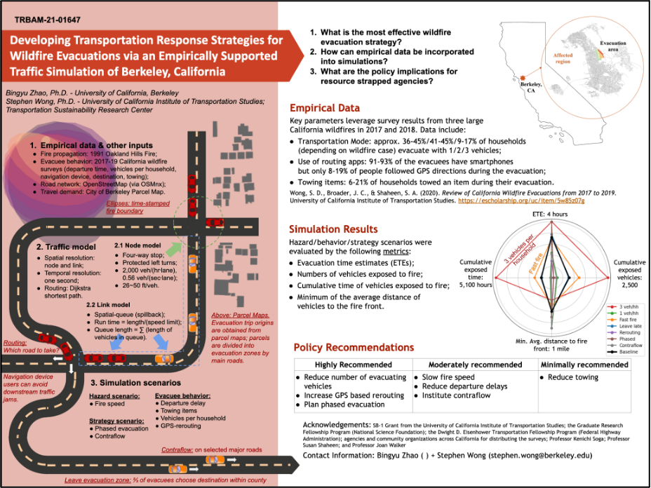
Figure 1. Modeling and policy implications for wildfire planning in Berkeley, CA.
Urban data analytics
Data analytics complements the modeling and simulations for the study of complex urban systems. In my research, I focus on the spatial aspects of urban “big data” and use techniques that include: spatial regressions, map joining, spatio-temporal visualization, etc. The research outcomes and current projects include:
- Spatial regression to analyze the degradation patterns of pavements in San Francisco based on two-decades of asset management data. ICE paper.
- Preference of travelers using road or public transportation in New York (with Tracy Tanusi).
- Model calibration:
-
- Using Google Maps API to obtain volume-delay curves for individual roads in London. DCE paper.
- Calibration of large-scale models using traffic sensor measurements in Tokyo.
-
- Emission and noise data analysis;
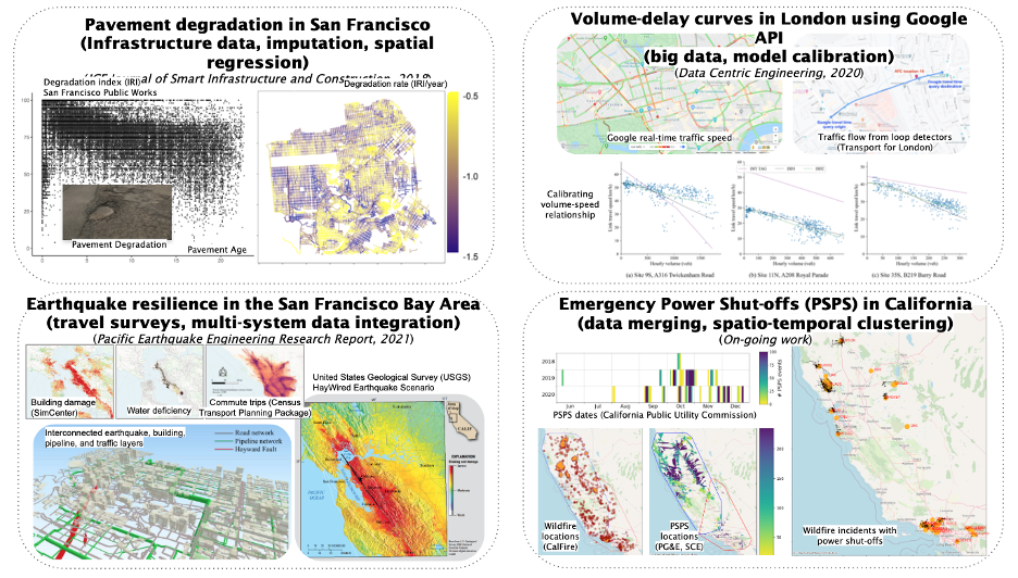
Figure 2. Infrastructure data analytics.
Social impacts
Through our research on wildfires, we frequently engage with community outreach. The key message that we relay is awareness raising both to the public and agencies. In 2021, my colleagues and I started to work on WUI-Go!, an academic-originated startup aiming to bring analytics and services to communities under wildfire risks for better preparedness.
I am one of the instructors for CE170: Infrastructure Sensing and Modeling. I volunteer regularly at the Lawrence Hall of Science to teach small kids and school children about engineering concepts.